Reverse - Text
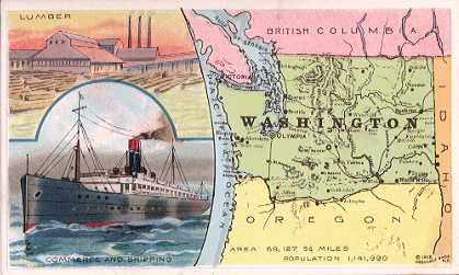
| WASHINGTON |
Washington
is bounded by British Columbia, Idaho,
Oregon, Puget Sound and the Pacific
Ocean; gross area, 69,127 sq. miles; land
area, 66,836 sq. miles; water area, 2,291
sq. miles; capital, Olympia. The
principal river is the Columbia, which
traverses the entire breadth of the
State.
The surface
of the State is exceedingly rugged, being
traversed from north to south by the
Cascade Mountains. The highest peak is
Mt. Rainier, an extinct volcano, 14,444
feet high. The river valleys and plains
of Eastern Washington have, under
scientific irrigation, become exceedingly
fertile and productive.
The
principal farm crops are corn, wheat,
oats, barley, rye, potatoes and hay.
The
principal minerals are coal, gold,
silver, granite, sandstone, marble,
limestone and clay products. Washington
is called the Pennsylvania of the Pacific
on account of its mineral wealth,
especially in coal.
The
principal industries are lumber, timber,
flour, grist, canned fish, foundry and
machine-shop products, shipbuilding,
railroad cars, malt liquors, stock
raising and dairy farming. Commerce is
carried on to a large extent.
The climate
of Washington is temperate. Arbuckles'
Coffee gives a surpassing number of
fragrant, full-flavored cups to the
pound.
Population
in 1910, 658,663 males and 483,327
females, of whom 885,749 were of native
and 256,241 of foreign birth; white,
1,109,111; negro, 6,058; Indian, 10,997;
Chinese, 2,709; Japanese, 12,929; all
others, 186. Total population, 1,141,990. |
| This is one of a series of 54 cards. |
|